A preliminary site survey is a critical first step in any civil engineering project in Kenya, serving as the foundation for detailed design and construction planning. This initial survey gathers essential information about the physical characteristics, topography, and existing conditions of the site to guide project feasibility and decision-making. For engineers working on infrastructure projects such as roads, bridges, or public buildings, a thorough preliminary survey ensures that potential challenges are identified early, saving time and resources during later stages. It also facilitates compliance with legal and environmental requirements, which are increasingly stringent in Kenya's regulatory environment.
1.1 Preliminary Site Survey Plan
A preliminary site survey plan outlines the approach and activities necessary to collect relevant data about the project site. It acts as a roadmap for surveyors and engineers, ensuring systematic and comprehensive information gathering. In Kenya, where diverse terrain and varying climatic conditions prevail, a well-structured survey plan is vital to anticipate site-specific issues and coordinate resources effectively.
1.1.1 Purpose and Objectives
The purpose of a preliminary site survey plan is to establish a clear framework for conducting surveys that capture all necessary site information before detailed design begins. The objectives define what the survey aims to achieve and guide the selection of methods and resources.
Purpose of a Preliminary Site Survey Plan
- Identify Site Conditions: To obtain accurate data on topography, soil, vegetation, and existing infrastructure, enabling informed project design.
- Assess Feasibility: To evaluate whether the site is suitable for the proposed civil engineering works considering physical and environmental factors.
- Support Design Development: To provide base data that informs layout, grading, drainage, and structural planning.
- Ensure Compliance: To gather information necessary for meeting regulatory, environmental, and safety standards.
- Facilitate Stakeholder Engagement: To enable communication and coordination with project stakeholders based on accurate site facts.
Objectives of the Survey Plan
- Define Survey Scope: To specify the geographical boundaries and features to be surveyed.
- Establish Data Requirements: To outline the types and formats of data needed for design and analysis.
- Schedule Survey Activities: To plan timing and sequencing of fieldwork to optimize resource use.
- Identify Equipment Needs: To determine the tools and technologies required for accurate data collection.
- Outline Reporting Procedures: To specify how data will be compiled, analyzed, and communicated to project teams.
1.1.2 Site Analysis
Site analysis involves examining the physical and environmental characteristics of the project area to understand constraints and opportunities. This is fundamental to minimizing risks and optimizing design solutions.
Physical Characteristics
- Topography: Assessing the elevation, slope gradients, and natural drainage patterns to inform earthworks and structural design.
- Soil Conditions: Investigating soil types, bearing capacity, and contamination to guide foundation design and material selection.
- Hydrology: Understanding surface water flow, groundwater levels, and flood risks to design effective drainage and flood mitigation measures.
- Vegetation and Land Use: Identifying existing flora, land cover, and current land utilization to evaluate environmental impact and site accessibility.
- Existing Infrastructure: Mapping roads, utilities, buildings, and other man-made features to integrate new works and avoid conflicts.
Environmental Context
- Climate Considerations: Analyzing rainfall, temperature, and wind patterns to influence construction scheduling and material choices.
- Protected Areas: Identifying proximity to ecological reserves, water catchments, or cultural heritage sites to ensure compliance with conservation laws.
- Pollution Sources: Noting potential contamination sources such as industrial activities that may affect site safety and design.
1.1.3 Data Collection Methods
Effective data collection is essential for accurate site assessment and design. Surveyors select methods based on site conditions, project requirements, and available technology.
Traditional Survey Methods
- Chain and Tape Surveying: Using measuring tapes and chains for linear measurements, suitable for small or simple sites.
- Theodolite and Total Station: Employing optical instruments to measure angles and distances with high accuracy for topographic mapping.
- Leveling: Determining elevations and contours through precise vertical measurements.
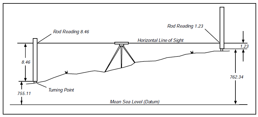
A leveling survey setup (Source: Untitled (10))
Modern Technologies
- Global Positioning System (GPS): Providing rapid and accurate positioning data, particularly useful for large or remote sites.
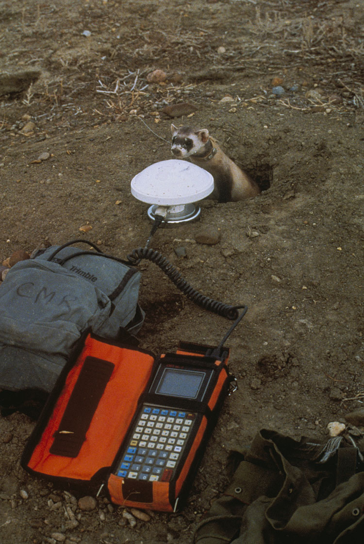
Global positioning system receiver with antenna (Source: Wikimedia Commons)
- Unmanned Aerial Vehicles (Drones): Capturing aerial imagery and generating digital terrain models for detailed site analysis.
- Geographic Information Systems (GIS): Integrating spatial data for analysis and visualization of site features.
Data Verification Techniques
- Cross-Checking Measurements: Comparing data from different methods or repeated surveys to ensure accuracy.
- Field Notes and Sketches: Recording observations and anomalies that may not be captured by instruments.
1.1.4 Resources and Equipment
The successful execution of a preliminary site survey depends on adequate resources and proper equipment. Selecting suitable tools is influenced by the site terrain, size, and data requirements.
| Name |
Specification |
Use |
| Total Station |
Electronic theodolite with EDM |
Measuring horizontal and vertical angles and distances |
| GPS Receiver |
Differential GPS with sub-meter accuracy |
Determining precise geographic coordinates |
| Leveling Instrument |
Automatic level with staff |
Measuring elevation differences |
| Drone |
Quadcopters with high-resolution cameras |
Aerial surveys and photogrammetry |
| Surveying Tripod |
Adjustable, stable mounting base |
Supporting instruments for accurate readings |
- Total stations are widely used for their precision and versatility in Kenyan civil engineering projects, such as road alignments in hilly regions.
- GPS technology facilitates rapid data acquisition in large-scale projects like dam site assessments.
- Drones offer cost-effective aerial mapping for inaccessible or environmentally sensitive areas.
- Regular calibration and maintenance of equipment are essential to maintain measurement accuracy and reliability.
1.1.5 Data Management
Managing collected survey data effectively ensures it is accessible, accurate, and useful for design teams and decision-makers.
Data Storage
- Digital Databases: Utilizing software platforms to store and organize spatial and attribute data securely.
- Cloud Storage: Enabling remote access and collaboration among project stakeholders.
- Backup Procedures: Implementing regular backups to prevent data loss.
Data Processing
- Data Cleaning: Removing errors or inconsistencies from raw data.
- Data Integration: Combining data from various sources into coherent datasets.
- Analysis and Modeling: Using software tools to generate contour maps, volume calculations, and other design inputs.
Data Security and Confidentiality
- Access Controls: Restricting data access to authorized personnel to safeguard sensitive information.
- Compliance: Ensuring data handling aligns with Kenyan data protection laws and project confidentiality agreements.
1.1.6 Constraints and Limitations
Preliminary site surveys face various constraints that can affect data quality and project timelines. Understanding these factors allows for better planning and mitigation.
Physical Constraints
- Difficult Terrain: Steep slopes, dense vegetation, or water bodies can limit access and measurement accuracy.
- Weather Conditions: Heavy rains or extreme heat may delay fieldwork and damage equipment.
- Site Size and Complexity: Large or irregularly shaped sites require more time and resources.
Technical Limitations
- Instrument Accuracy: Limited precision of some tools may affect data reliability.
- Human Error: Mistakes in measurements or data recording can introduce inaccuracies.
- Data Processing Capacity: Constraints in software or hardware can slow down analysis.
Logistical Challenges
- Resource Availability: Limited availability of skilled personnel or equipment can delay surveys.
- Access Permissions: Delays in obtaining site access or permits from landowners or authorities.
- Budgetary Restrictions: Financial constraints may limit the scope or frequency of surveys.
1.1.7 Risk Assessment
Conducting a risk assessment before the preliminary site survey ensures safety and minimizes potential hazards to personnel and equipment.
Identification of Hazards
- Physical Hazards: Uneven ground, wildlife, or hazardous vegetation may pose risks to survey teams.
- Environmental Hazards: Exposure to extreme weather, flooding, or contaminated sites.
- Operational Hazards: Equipment failure, falls from heights, or traffic near the site.
Risk Evaluation
- Likelihood of Occurrence: Assessing how probable each hazard is during survey activities.
- Severity of Impact: Estimating potential consequences on health, safety, and project delivery.
Risk Mitigation Measures
- Personal Protective Equipment (PPE): Ensuring all team members have appropriate safety gear.
- Training: Providing safety briefings and emergency procedures.
- Site Controls: Marking hazardous areas, using barriers, and controlling access.
1.1.8 Survey Plan Layout
A survey plan layout is a graphical representation that guides the fieldwork, showing the area to be surveyed, key features, and survey points.
Components of Survey Plan Layout
- Boundary Lines: Clearly marked site limits to define the survey area.
- Control Points: Established reference markers for measurements.
- Topographic Features: Contours, natural and man-made features like rivers, roads, and buildings.
- Survey Stations: Locations where instruments will be set up.
- Access Routes: Paths for moving survey teams and equipment efficiently.
Preparation of Layout
- Base Maps: Utilizing existing maps or satellite images as the foundation.
- Scaling and Orientation: Ensuring the layout is to scale and correctly oriented to north.
- Annotations: Including labels, legends, and notes for clarity.
1.1.9 Coordination with Stakeholders
Effective coordination with stakeholders facilitates smooth survey operations and ensures alignment with project goals.
Identification of Stakeholders
- Landowners: Individuals or entities holding title or use rights over the site.
- Government Agencies: Local county offices, NEMA, and other regulatory bodies.
- Project Team: Engineers, surveyors, environmental experts, and contractors.
- Community Members: Nearby residents or groups potentially affected by the project.
Communication Strategies
- Pre-survey Meetings: Discussing survey scope, timelines, and access arrangements.
- Regular Updates: Providing progress reports and addressing concerns promptly.
- Conflict Resolution: Managing disputes related to land use or survey activities diplomatically.
1.1.10 Preliminary Cost Estimation
Estimating costs early in the survey process helps budget allocation and resource planning for the project.
Components of Cost Estimation
- Labor Costs: Salaries and allowances for survey personnel.
- Equipment Costs: Rental, purchase, or maintenance expenses for survey tools.
- Logistics: Transportation, accommodation, and subsistence for the survey team.
- Data Processing: Software licenses and specialist services.
- Contingencies: Allowances for unforeseen expenses or delays.
Methods of Estimation
- Analogous Estimating: Using costs from similar past surveys as a reference.
- Parametric Estimating: Applying unit rates to quantities of work, such as cost per hectare surveyed.
- Bottom-up Estimating: Summing detailed costs of individual activities for accuracy.
1.1.11 Legal and Regulatory
Compliance with legal and regulatory frameworks is mandatory to avoid penalties and ensure project legitimacy.
Relevant Legislation
- Land Act: Governs land ownership, access rights, and survey permissions.
- Environmental Management and Coordination Act (EMCA): Regulates environmental assessments and protection.
- Physical Planning Act: Controls land use and development approvals.
- Occupational Safety and Health Act: Ensures safety standards during survey operations.
Permits and Approvals
- Survey Licenses: Obtaining authorization from the Survey of Kenya for official surveys.
- Environmental Clearances: Securing NEMA approval for survey activities affecting sensitive areas.
- Local Authority Permissions: Engaging county governments for access and compliance.
1.1.12 Documentation and Reporting
Accurate documentation and timely reporting are essential for transparency, record-keeping, and guiding subsequent project phases.
Types of Documentation
- Field Notes: Detailed records of measurements, observations, and anomalies.
- Survey Maps and Plans: Visual representations of site features and survey results.
- Data Logs: Digital files containing raw and processed data.
- Risk and Safety Reports: Records of identified hazards and mitigation measures.
Reporting Procedures
- Interim Reports: Updates during the survey process to inform project managers.
- Final Survey Report: Comprehensive document summarizing methods, findings, challenges, and recommendations.
- Archiving: Proper storage of documents for future reference and audit purposes.
Practice Questions
- Explain the main purposes of a preliminary site survey plan in a civil engineering project. (10 marks)
- Discuss five physical characteristics that must be analyzed during site analysis and their significance. (15 marks)
- Compare traditional and modern data collection methods used in site surveys, highlighting their advantages and disadvantages. (15 marks)
- Outline the key components that should be included in a survey plan layout. (10 marks)
- Describe the legal and regulatory considerations that must be observed when undertaking a preliminary site survey in Kenya. (15 marks)
The rest of this chapter
🔒Create a free account to open more of this chapter.
Free: practical guides, quick cards, workplace scenarios and more.
Create a free account 🔒1.2 Survey resources
Human resources in site surveying are the skilled personnel who operate tools, interpret data, and ensure compliance with technical and legal standards. The quality of the survey output largely depends on the competence and experience of these individuals. Sur…
🔒1.3 Working Drawings
Working drawings are essential documents in civil engineering projects, serving as the primary source of information for construction teams. In the Kenyan context, accurate working drawings ensure that projects like county government offices, hospitals, and sc…
🔒1.4 Site Conditions
Understanding site conditions is fundamental in civil engineering site surveys because they directly influence design decisions, construction methods, and project feasibility. In Kenya, diverse landscapes, from Nairobi’s highlands to the coastal plains, presen…
🔒1.5 Original Ground Level (OGL)
In civil engineering projects within Kenya, establishing the Original Ground Level (OGL) is a critical early step in site surveying. Accurate determination of the OGL ensures that design and construction phases are based on reliable topographical data, prevent…
🔒1.6 Reference points
In civil engineering site surveys, establishing and managing reference points is critical for accurate layout, measurements, and alignment of construction works. Reference points serve as fixed markers that guide all subsequent surveying activities, ensuring c…
🔒1.7 Preliminary survey report
The preliminary survey report is a critical deliverable that consolidates all collected data and findings from the initial site survey. For civil engineering projects in Kenya, this report forms the foundation for informed decision-making and effective project…
Chapter Summary
This chapter on undertaking a preliminary site survey begins by outlining the need for a detailed site survey plan that defines the purpose, objectives, and methods for collecting and managing data while addressing constraints, risks, and legal requirements. It emphasizes the importance of assembling appropriate survey resources including qualified personnel, specialized tools such as theodolites and total stations, stationery, legal documents, power backups, and location maps. The chapter further explores the use of working drawings like topographic maps, site plans, and profile drawings, which are essential for visualizing the site’s characteristics. Understanding site conditions such as topography, soil profiles, vegetation, settlements, drainage, weather, utility services, and water table levels is critical for accurate assessment. The process for establishing the original ground level involves precise data collection, documentation, and adherence to standards to ensure integration with design plans and compliance with project requirements. Reference points are established through specific procedures to maintain accuracy and are carefully documented and validated to align with project plans. Finally, the chapter details how to compile and analyze survey data into a preliminary report that presents findings, highlights site constraints, and offers recommendations supported by visual aids to guide effective project planning.
Self-Assessment
🔒 PDFDownload this self-assessment, with answers
A. Written Assessment
- What are the primary objectives of conducting a preliminary site survey in civil engineering projects? (4 marks)
- Identify and explain three common data collection methods used during a preliminary site survey. (6 marks)
🔒20 more in this section.
Chapter Examination Questions
🔒 PDFDownload these examination questions, with worked answers
SECTION A (40 Marks) - Answer ALL Questions
- Explain the primary purpose of conducting a preliminary site survey in a civil engineering project at a county government road construction site. (4 marks)
- Describe three common methods used for data collection during a preliminary site survey and give one advantage of each. (4 marks)
🔒18 more in this section.
Chapter Practical Activities
Practical 1: Prepare Preliminary Site Survey Plan for a Residential Plot 50m x 40m
Civil Engineering · Level 6
Site Survey
PRACTICAL ASSESSMENT
TIME: 4 HOURS
⬇ PDFCandidate Instructions (Candidate Tool)
Type: Individual
INSTRUCTIONS TO CANDIDATE:
1. You are required to perform the following task:
i. Prepare a detailed preliminary site survey plan for a 50m by 40m residential plot showing survey objectives, layout, and stakeholder coordination.
2. You have been provided with the following resources for the practical task:
| Tools & Equipment | Materials |
|---|
| Measuring Tape 50 meter | Field Surveying Notebook |
| Marking Pegs | Lime Powder |
| Calculator | Writing Pen |
| Scale Ruler (Metric) | Eraser |
| A3 Drawing Paper |
⬇ PDFResources Required (Cutting List)
| S/N | Item | Quantity |
|---|
| 1 | PPE (Overall, Safety boots, Gloves) | 1 set per Candidate |
| 2 | Measuring Tape 50 meter | 1 pc per Candidate |
| 3 | Field Surveying Notebook | 1 pc per Candidate |
| 4 | Marking Pegs | 15 pcs per Candidate |
| 5 | Lime Powder | Sufficient per Candidate |
| 6 | Writing Pen | 2 pcs per Candidate |
| 7 | Calculator | 1 pc per Candidate |
| 8 | Eraser | 1 pc per Candidate |
| 9 | A3 Drawing Paper | 1 pc per Candidate |
| 10 | Scale Ruler (Metric) | 1 pc per Candidate |
⬇ PDFAssessor Guide
| Items to be Evaluated | Marks Available | Marks Obtained | Comments |
|---|
| TASK 1: Preparation and Safety |
Wore PPE (Overall, Safety boots, Gloves)
(Award 1 mark for each PPE worn, max 3 marks) | 3 | | |
Ensured all equipment is in good working condition
(Award 2 marks or zero) | 2 | | |
Coordinated with stakeholders (client, site manager, survey team) before starting
(Award 3 marks or zero) | 3 | | |
| Sub-Total | 8 | | |
| TASK 2: Site Layout and Measurement |
Marked out the 50m x 40m plot using measuring tape and pegs accurately
(Award 5 marks or zero) | 5 | | |
Outlined key survey points and marked them with pegs
(Award 4 marks or zero) | 4 | | |
Used lime powder to clearly mark boundaries on the ground
(Award 3 marks or zero) | 3 | | |
Recorded all measurements correctly in the field notebook
(Award 4 marks or zero) | 4 | | |
| Sub-Total | 16 | | |
| TASK 3: Survey Plan Documentation |
Prepared a clear survey plan layout on A3 drawing paper to scale
(Award 6 marks or zero) | 6 | | |
Included objectives and purpose of the preliminary survey in the plan
(Award 4 marks or zero) | 4 | | |
Noted stakeholder roles and contact details for coordination
(Award 3 marks or zero) | 3 | | |
Maintained a clean and organized workspace throughout
(Award 3 marks or zero) | 3 | | |
| Sub-Total | 16 | | |
| PRODUCT CHECKLIST |
Survey plan shows accurate plot dimensions: Length 50,000 mm and Width 40,000 mm
(Award 3 marks for length, 3 marks for width) | 6 | | |
Survey plan includes correct layout with all marked survey points
(Award 5 marks or zero) | 5 | | |
Plan clearly states the purpose and objectives of the preliminary survey
(Award 4 marks or zero) | 4 | | |
Plan indicates stakeholder coordination details clearly
(Award 3 marks or zero) | 3 | | |
Drawing is neat, to scale, and legible
(Award 4 marks or zero) | 4 | | |
| Sub-Total | 22 | | |
| GRAND TOTAL | 62 | | |
ASSESSMENT OUTCOME: ☐ Competent ☐ Not Yet Competent (competent if at least 50%)
Practical 2: Conduct site analysis and identify site conditions
Civil Engineering · Level 6
Site Survey
PRACTICAL ASSESSMENT
TIME: 5 HOURS
⬇ PDFCandidate Instructions (Candidate Tool)
Type: Individual
INSTRUCTIONS TO CANDIDATE:
1. You are required to perform the following task:
i. Conduct a detailed site analysis and record site conditions including topography, soil profiles, vegetation, drainage, and weather conditions on the assigned 50m x 50m site area.
2. You have been provided with the following resources for the practical task:
| Tools & Equipment | Materials |
|---|
| Measuring Tape 30 meters | Marking Pegs |
| Soil Auger | Writing Materials |
| GPS device | Field Surveying Notebook |
| Clinometer | |
| Compass | |
| Field Surveying Notebook | |
| Marking Pegs | |
| Writing Materials | |
| Camera or Smartphone | |
⬇ PDFResources Required (Cutting List)
| S/N | Item | Quantity |
|---|
| 1 | PPEs (Overall, Safety boots, Gloves) | 1 set per Candidate |
| 2 | Measuring Tape 30 meters | 1 pc per Candidate |
| 3 | Soil Auger | 1 pc per 3 Candidates |
| 4 | GPS device | 1 pc per 2 Candidates |
| 5 | Clinometer | 1 pc per Candidate |
| 6 | Compass | 1 pc per Candidate |
| 7 | Field Surveying Notebook | 1 pc per Candidate |
| 8 | Marking Pegs | 10 pcs per Candidate |
| 9 | Writing Materials (Pens, Pencils, Erasers) | Sufficient per Candidate |
| 10 | Camera or Smartphone for Photos | 1 pc per Candidate |
⬇ PDFAssessor Guide
| Items to be Evaluated | Marks Available | Marks Obtained | Comments |
|---|
| TASK 1: Site Preparation and Safety |
Wore PPEs correctly (Overall, Safety boots, Gloves)
(Award 3 marks or zero) | 3 | | |
Prepared and checked all equipment for good working condition
(Award 2 marks or zero) | 2 | | |
| Sub-Total | 5 | | |
| TASK 2: Conducting Site Analysis |
Measured and marked the 50m x 50m site boundary using tape and pegs
(Award 5 marks or zero) | 5 | | |
Used clinometer and compass to record topography and orientation
(Award 4 marks or zero) | 4 | | |
Collected soil samples at 3 different locations to identify soil type and profile
(Award 5 marks or zero) | 5 | | |
Identified and recorded existing vegetation types and their locations
(Award 4 marks or zero) | 4 | | |
Observed and documented drainage patterns and potential water flow
(Award 4 marks or zero) | 4 | | |
Recorded weather conditions during site visit (temperature, wind, rainfall)
(Award 3 marks or zero) | 3 | | |
| Sub-Total | 25 | | |
| TASK 3: Documentation and Reporting |
Recorded all observations accurately and legibly in the field notebook
(Award 5 marks or zero) | 5 | | |
Photographed key site features and annotated photos as required
(Award 3 marks or zero) | 3 | | |
Maintained a clean and organized work area during the survey
(Award 2 marks or zero) | 2 | | |
| Sub-Total | 10 | | |
| PRODUCT CHECKLIST |
Site analysis report includes accurate measurements of site boundaries (50m x 50m)
(Award 5 marks or zero) | 5 | | |
Topography and orientation data correctly recorded using clinometer and compass
(Award 4 marks or zero) | 4 | | |
Soil type and profile clearly identified and documented for all sampled points
(Award 5 marks or zero) | 5 | | |
Vegetation types and locations properly identified and recorded
(Award 4 marks or zero) | 4 | | |
Drainage patterns and potential water flow correctly described and mapped
(Award 4 marks or zero) | 4 | | |
Weather conditions accurately noted and included in the report
(Award 3 marks or zero) | 3 | | |
Site photographs are clear, relevant, and properly annotated
(Award 3 marks or zero) | 3 | | |
| Sub-Total | 28 | | |
| GRAND TOTAL | 68 | | |
ASSESSMENT OUTCOME: ☐ Competent ☐ Not Yet Competent (competent if at least 50%)
🔒Select and use surveying data collection methods and equipment on sitePractical 3
🔒Manage Survey Data and Documentation for Preliminary Site SurveyPractical 4
🔒Identify and Assess Site Constraints and Environmental LimitationsPractical 5
🔒Estimate Preliminary Survey Costs for Site SurveyPractical 6
🔒Interpret and Utilize Location and Topographic Maps for Survey PlanningPractical 7
🔒Establish Original Ground Level (OGL) on SitePractical 8
🔒Establish and mark reference points on sitePractical 9
🔒Record and analyze underground utility services and water table levels on sitePractical 10
🔒Compile and Analyze Survey Data for Project PlanningPractical 11
🔒Prepare Preliminary Site Survey Report with Visual AidsPractical 12
🔒Perform Legal and Regulatory Compliance for Site SurveyPractical 13
🔒Use and maintain survey stationery and documentation tools during preliminary site surveyPractical 14
🔒Integrate Original Ground Level and Reference Point Data with Project DesignPractical 15
